Land Surveying
Land Surveying is the process by which a surveyor measures certain dimensions that generally occur on the surface of the earth using modern surveying equipments, They produce maps with accurate measurement of angular deviation, horizontal, vertical and slope distances. From these measurements they calculate the area and volume required for different construction works. The knowledge of engineering graphics is also required to plot the maps.
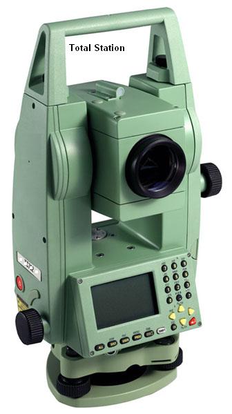
Sophisticated equipments like theodolite, digital level, total station, compass, distometer, clinometer, planimeter, levelling staff etc. are required to measure the distance and angle with high degree of precision.
Latest techniques of GPS (Global Positioning System) and Remote Sensing are also being used by surveyors.
Land surveying plays an important role in construction process of buildings, roads, canals, dams, bridges etc.
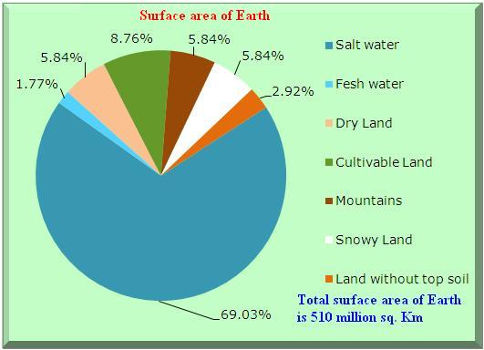
Do you know that the total surface area of the Earth is 510 million km2. 29.2% of this area is covered by land (149 million km2), and 70.8% of this area is covered by water (361 million km2).
Related Links
Stress Transformation Calculator
Calculate Principal Stress, Maximum shear stress and the their planes
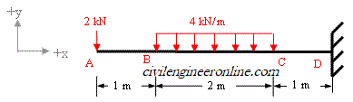
Calculator for Moving Load Analysis
To determine Absolute Max. B.M. due to moving loads.
Bending Moment Calculator
Calculate bending moment & shear force for simply supported beam
Moment of Inertia Calculator
Calculate moment of inertia of plane sections e.g. channel, angle, tee etc.
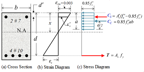
Reinforced Concrete Calculator
Calculate the strength of Reinforced concrete beam
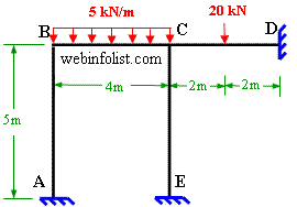
Moment Distribution Calculator
Solving indeterminate beams
Deflection & Slope Calculator
Calculate deflection and slope of simply supported beam for many load cases
Fixed Beam Calculator
Calculation tool for beanding moment and shear force for Fixed Beam for many load cases
BM & SF Calculator for Cantilever
Calculate SF & BM for Cantilever
Deflection & Slope Calculator for Cantilever
For many load cases of Cantilever
Overhanging beam calculator
For SF & BM of many load cases of overhanging beam
Civil Engineering Quiz
Test your knowledge on different topics of Civil Engineering
Research Papers
Research Papers, Thesis and Dissertation
List of skyscrapers of the world
Containing Tall buildings worldwide
Forthcoming conferences
Containing List of civil engineering conferences, seminar and workshops
Profile of Civil Engineers
Get to know about distinguished Civil Engineers
Professional Societies
Worldwide Civil Engineers Professional Societies
Keep visiting for getting updated or Join our mailing list
PleaseTell your Friends about us if you find our website useful